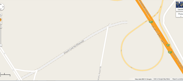
Google map has started showing the planned kashmir highway which starts from motorway and goes right into the airport while clearly giving link road to the PECHS Society.
This planned Kashmir Highway is the lifeline for all societies operating near the New Islamabad Airport i.e. PECHS, Top City-1 and Mumtaz City. All three societies are expecting bigger chunk of expected investment in this area. This projection clarifies a number of doubts of investors who are confused about the possible entrance gate to the airport and whether PECHS is going to get entrance from Kashmir Highway or not.
If PECHS gets a link road from the spot where it touches the Kashmir Highway as projected in the map, PECHS becomes the closest society to the New Airport and hence gets the major attention from Investors.
We have embedded the google map below by pointing out the projected Kashmir Highway, you can drag the map to see the destination of this planned road.