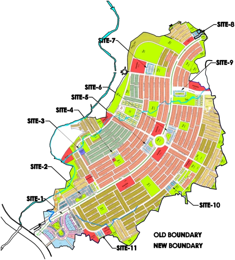
This interactive map of DHA Phase 4 Islamabad provides a detailed view of the society's layout. Visitors can easily navigate through different sectors, identify main roads, parks, mosques, and commercial areas. The map is designed to help potential buyers and residents understand the spatial arrangement of the phase, locate specific blocks, and visualize the proximity of amenities. Use this map to get a clear understanding of the development plan and the placement of various plots and facilities within DHA Phase 4.
DHA Phase 4 Islamabad Map
Explore DHA Phase 4 Islamabad's layout, sectors, and plot locations with our interactive society map.
Loading map controls…
Location and Access
- Main access: Main GT Road
- Nearest interchange / major junction: Bahria Town Phase 8 Bridge Over Soan River
- Located alongside the Soan River.
- Accessible via GT Road and Adyala Road.
- Connects to DHA Phase I Orchard Sector C.
- Proximity to the Rawalpindi Ring Road.
- Close to Askari 14 and Army Officers Colony.
What Is Shown on the Society Map
- Clearly demarcates Sectors Overseas, A, B, C, and D.
- Shows main internal roads like 'Main Link Road' and 'River View Road'.
- Highlights green spaces including parks and a lake.
- Marks the location of a mosque.
- Indicates commercial areas and mixed-use zones.
- Depicts apartment zones.
- Includes 'DHA Reserve' and 'Hill Top Area'.
- Shows 'ARL Park Area' with specific plot sizes.
- View the calibrated society plan over the Google satellite map.
- Zoom in to understand roads, blocks, plot numbering and surrounding access.
- Use GPS to check your current position while visiting the society.
- Open available property and project pins for their basic details.
Available Property Types and Sizes
- 5 Marla Residential
- 10 Marla Residential
- 1 Kanal Residential
- 4 Marla Commercial
- 8 Marla Commercial
Within 10 km
Important Nearby Landmarks
Approximate straight-line distance from the map centre. Only established, recognisable landmarks are shown.
Bahria International HospitalHospital
Foundation University Rawalpindi CampusUniversity
Amazon MallShopping Landmark
Giga MallShopping Landmark
Rawalpindi Railway StationRailway Station
Map-linked inventory
12 active listingsProperties Available on This Map

Residential Property
1 Kanal Plot Up for Sale in Sector A, River View North DHA Phase 4 Islamabad
1 kanal · Plot 18Rs 21,000,000
Residential Property
1 Kanal Plot Available in Sector A, River View North DHA Phase 4 Islamabad
1 kanal · Plot 8 · Street 2Rs 20,000,000
Residential Property
1 Kanal Plot Up for Sale in Sector A, River View North DHA Phase 4 Islamabad
1 kanal · Plot 2 · Street 10Rs 19,000,000
Residential Property
Attractive Deal: 10 Marla Plot for Sale in Sector A, DHA Phase 4 Islamabad
10 marla · Plot 31 · Street 10Rs 17,500,000
Residential Property
Reasonable Demand: 10 Marla Plot for Sale in Sector A, DHA Phase 4 Islamabad
10 marla · Plot 14 · Street 18Rs 16,800,000
Residential Property
Urgent Sale: 10 Marla Plot for Sale in Sector A, DHA Phase 4 Islamabad
10 marla · Plot 5 · Street 17Rs 16,400,000
Residential Property
Ideal Investment: 10 Marla Plot Up for Sale in Sector A, DHA Phase 4 Islamabad
10 marla · Plot 36 · Street 15Rs 17,500,000
Residential Property
Affordable Option: 10 Marla Plot Available in Sector A, DHA Phase 4 Islamabad
10 marla · Plot 7 · Street 18Rs 16,500,000
Residential Property
Prime Location: 10 Marla Plot for Sale in Sector A, DHA Phase 4 Islamabad
10 marla · Plot 35 · Street 16Rs 17,500,000
Residential Property
Hot Location: 10 Marla Plot Available in Sector A, DHA Phase 4 Islamabad
10 marla · Plot 8 · Street 18Rs 17,500,000
Residential Property
8 Marla Corner Plot for Sale in DHA Phase 4 River View North Rawalpindi
8 marla · Plot 34 · Street 06Rs 9,500,000
Residential Property
7th Avenue Corner (flat Plot): Sector D, DHA Phase 4 Islamabad 10 Marla Plot for Sale
10 marla · Plot 15Rs 17,000,000